The success or failure of your next environmental drilling project in West Texas or Eastern New Mexico may depend on having enough information about the physical and geologic settings of the Ogallala Aquifer at your site. These factors can have a big influence on how the work is conducted, its safe and profitable outcome and on minimizing the potential for an adverse impact on the environment.
What is the impact of drilling on the environment?
A borehole or groundwater monitor well is a potential pathway for an adverse impact to subsurface soil and groundwater. An improperly installed borehole or groundwater monitor well can allow vertical movement of contamination or groundwater. One common drilling problem that is encountered is smearing of contaminated soil down a borehole which could cause new contamination at a greater depth. Another adverse impact is drilling through multiple water bearing zones without proper borehole casing. This can cause contaminated or saline groundwater to move vertically, particularly if deeper saline groundwater is under artesian pressure, and has the potential to contaminate otherwise clean groundwater zones. Drilling in sensitive and economically important formations can also present challenges to your environmental drilling project.
What is the Ogallala Formation in Texas and New Mexico?
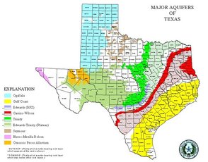
The Ogallala Formation is one of the largest groundwater aquifers in the world. The Ogallala Aquifer extends across eight states from Texas, New Mexico, Colorado, Oklahoma, Kansas, Nebraska, South Dakota and North Dakota. The Ogallala Aquifer in the High Plains of Texas is the major and sometimes the only source of groundwater in the High Plains from Midland to north of Amarillo. This vital resource is critical to the economic survival of the region.
The Ogallala Aquifer was deposited with gravel, sand, clay and silt eroding from the Rocky Mountains some 10 to 12 million years ago during the Tertiary age. These sediments were carried away to the southeast by streams flowing across a deeply eroded landscape (similar to the area east of the High Plains today). Sediment filled the eroded features in the landscape of the older rocks, until a relatively flat and gently southeast sloping plain was created.
How Should You Drill in the Ogallala Formation?
Good planning and use of the best drilling techniques will help you complete your project without adverse environmental impact to the Ogallala. Factors to consider include caliche common in the uppermost Ogallala Formation, maintaining an open borehole and controlling the loss or gain of groundwater during drilling. Borehole casing and use of air and mud rotary drilling methods in the right circumstances are important when drilling in the Ogallala Formation.
Talon/LPE is experienced in drilling in the Ogallala Aquifer. We have installed over 5,000 soil borings, groundwater monitor wells and groundwater recovery wells in the Ogallala Aquifer in Texas and New Mexico. Talon/LPE has installed groundwater monitor wells up to 900 feet deep and are considered very knowledgeable with the Ogallala’s stratigraphy, red beds and depths to groundwater. Our expertise in drilling can help make your environmental drilling project a success.

